Sunday, March 26, 2017

Dayhike in Mt. Batolusong (Team Tiki-Tiki) // March 26, 2017

Skyy was the one who initiated to have a day hike.   During the week-long planning, we considered some of the mountains near Manila.  Eventually, I suggested climbing Mt. Batolusong due to an unfinished business.   The last time we've been here, Ana and I wasn't able to reach the summit due to heavy rain.  We had no clearing...no sea of clouds...just thick layers of fog.  The 2 agreed to me and during that week, Team Tiki-Tiki (a word derived after our Mt. Halcon's climb) was formed.  
------------
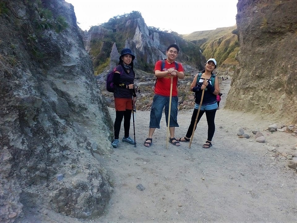
The Rangyas Peak taken at Mapatag Plateau
For the second time, It was a sweet revenge conquering the peak of this mountain in less than an hour!

The Hike (Photo Blast)

The community
Ate Nimfa, our tour guide
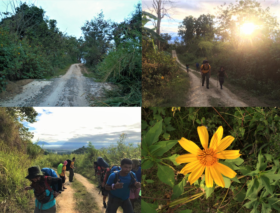
The trail of Mt. Batolusong is straightforward; chances of being lost is remote.  It begins by passing in a small community and rice fields; followed by a moderate assault in a woodland.  A wonderful open grass field awaits at the top.
A popular rock formation
Late sunrise and sea of clouds
Mama Skyy, the mastermind
The landscape of the grassland and nearby mountains
Assault to Rangyas Peak
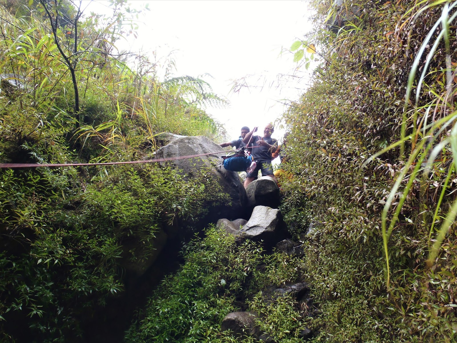
The last portion is quite technical; it is a short 4-wheeled assault on rocks.

A trail of bamboos 
Other hikers assaulting the Rangyas Peak

Team Tiki-Tiki at the summit
Descent going to Kay Ibon Falls
We just stayed at the summit for 10 minutes.  The sun is scorching and it is truly exhausting to stay there for a long time.  We managed to take some photos at the plateau before proceeding to Kay Ibon Falls.

Out Signature Pose

Jerico is fond of doing jump shots
I would like to call this "Rigor's Pose", originated from a fellow hiker.  I still don't have my own version :D
Her crossed-leg pose
 Kay Ibon Falls
The Falls
We didn't encounter other hikers on the falls; perhaps, it is due to the reason that traverse to the highway is no longer allowed.  
The picture beside the falls
Ate Nimfa while resting :D
We had our early lunch before going back to the jump-off.
Base Camp at San Andres
Beer moments at the Base Camp
Group picture before going home at Brgy. Hall
Walk away quietly in any direction and taste the freedom of the mountaineer - John Muir
Actual Itinerary
March 26, 2017 (3:00 AM): Departure Jollibee Farmers to Brgy. San Andres, Tanay Rizal
March 26, 2017 (4:00 PM): Arrival Cubao

Going There
1. Take any PUV in Cubao (Famers Area) or Ligaya (near Robinson Metroeast and Sta Lucia) going to Cogeo (Gate 2).
2. From gate 2 there is a terminal of jeepneys going to Sampaloc (usually leaving at 5 am).  Tell the driver to drop you at Batangasan.

3. From Batangasan, there are tricycles which can take you to Brgy. San Andres (jump-off)


Note
As of the writing, traverse to Highway is no longer allowed.  

Safe Budget
600 per head (for a group of 3)

Major Expenses
Guide Fee: 500 Php (5:1)
Registration Fee: 100 Php per head

Worth Remembering (Moments and Thoughts to Look Back)
- Team Tiki-Tiki before it became "Mga ****"
- Ang mahal naman ng registration fee nyo! (Skyy)
- Aamin na po ako, hinihingal na ko.  Ang bilis niyo po (Ate Nimfa).
- Discussion regarding Skyy's medical certificate issue after our Mt. Halcon's climb.
- Early lunch at Kay Ibon Falls
- Beer moments at the base camp
- Bawal po samin uminom pag may ginaguide kami (Ate Nimfa)
- Okay lang yan ate tapos na naman ang trabaho mo (Skyy to Ate Nimfa :P)
- Ate ihing-ihi na ko (Skyy nagtitipid ng 50 pesos)

Photo Credit: Skyy Chiong and Jerico Tabuzo
End
-JSC

Wednesday, March 22, 2017

A tour to the shrine and church of St. Andrew Kim Tae Gon // March 5, 2017

I joined the future couple (Dave and She) when they visited the Shrine of St. Andrew Kim Tae Gon in Bocaue, Bulacan over the weekend.  He is a Korean priest who became a refugee in Lolomboy, due to the outbreak of civil war in China.  He was canonized by St. John Paul II on May 6, 1984, and was enthroned as the secondary patron saint of Lolomboy Parish.  

Simbahan ng Sto. Cristo at San Andres Kim Taegon

We initially paid our visit and attended the Sunday mass in the under the constructed church of St. Andrew and Sto. Cristo.  Sto. Cristo is the primary patron saint of Lolomboy.


Schedule of masses
Structure of the church outside
 The inside of the church

The altar
The altar
The altar

Chapels

Sunken Chapel
A mini chapel dedicated to St. Pedro Calungsod
The future happy couple.... kailan nga ba talaga ang kasal?
Picture with St. Andrew
The Shrine


What makes this shrine unique is the Korean inspired ambiance.  We saw Korean sisters performing their mundane tasks (gardening, meditating, etc.).  I would like to emphasize that this is a shrine, not a temple.  We were corrected by a nun who overheard our conversation.  We found out that a temple is generally a place for worship; while a shrine is intended to venerate a certain individual of greatness (it can be a saint, a highly influential leader in the past, and the like).


pavilion
Mini Chapel


The altar
The chapel's ceiling
Bamboo Garden


Bamboo Garden
Ayns and She
The Couple
A leading path to heaven
Inside of the adoration chapel

Dave while praying
The Cross
Inside of their main chapel


Main Chapel
A nun while meditating
At the memorial statue of St. Andrew Kim

Reaching him :D
At the other garden
Last minute Photos

The gate's arc
At the other side
A self proclaimed Korean
Ayns
Development are still in progress
Going Back to Manila


Having a late breakfast
Ayun.... pagod silang umuwe :D
How we went there?
1. Take a bus bound to Malanday

2. Upon reaching Malanday, ride a jeep bound to Bocaue or Balagtas tell the driver to drop you at McDonald in Lolomboy.  The Parish is located 50 meters away from the tricycle terminal; while the shrine is 100 m away.
-JSC
End

Thursday, March 2, 2017

Delta V via Sapang Uwak: The true form of Mt. Pinatubo // February 18 to 21, 2017

Ampy, I and Ana along the trail (February 2016)
At the crater (February 2016)
It's been a year since my first climb to Mt. Pinatubo.  It all started when Ana, Ampy, and I joined an organized climb, to the commonly ventured Capas trail (a.k.a 4x4 trail).  Mt. Pinatubo brought me to a new world of excitements, challenges, and discoveries.  A surging wanderlust has been awakened from my inner self, followed by series of climbs and travels.

I didn't expect that my anniversary climb this February will be that same mountain through the more challenging Sapang Uwak trail.  This time I witnessed the true form of Mt. Pinatubo; a far cry from what I encountered before.
---------------------------------------------------------------------------------
At Mabalacat Terminal, waiting for the jeepney
We arrived in Mabalacat Terminal at 2:30 am.  We were fetched by a jeepney to Brgy. Sapang Uwak.  The entry point has a strict security and a permit must be secured prior to a climb.  Our guides joined us along the way.  At the end of the route is a rough road where extensive march begins.  


The Trail


Day 1


An open trail and sunflower plants alongside
Nipa hut is their typical housing style, but I saw some concrete structures
Meet and greet with the locals.  Aetas are the indigenous dwellers of this place.  The man in the middle of the first image is the village's captain.  He was already the captain before the 1991 volcanic eruption.  
Mt. Arayat at a distance

Their version of tobacco.  A stick is good for 3 days
The first rope segment.  Most of the trails are comprised of bamboos and other thorny plants.  One wrong move and you will surely have a striking token from the mountain.  lolx
Stream crossing.  We were in a hurry due to impending rain. This is a flash flood prone area and the water current can knock you down.
This part of the stream has both hot and cold flows.  I think the hot water is already near the boiling point.  So, Mt. Pinatubo is still active?
A native chick (labuyo) caught by our guide.
Some Landscape
Waterfalls

1st waterfalls
Picture taken at the 2nd waterfalls
Dinner Preparation.  We camped beside the stream (last water source)
Day 2

Our guide suggested that we break camp at 3 am but, we resumed the trek at 10 in the morning.  The weather was not good.  The rain poured down and the surroundings became foggy.  The clearing improved during the afternoon.  


Rommel while preparing the breakfast.  His signature dinakdakan, tomato omelette, and fried fish
Having a morning cheers before the breakfast.  Nauna mag inuman bago lagyan ng laman ang tiyan :o
Morning photo ops besides the stream (water source).  Choy and Yzella (father and daughter)
Break Camp
Group picture at 10 am before resuming the hike. L-R (Toytoy our tour guide, Luisa (a.k.a "pot", Rommel, Binsoy (Doc), Choy, Yzella, Katharine (a.k.a "Aling Simang"), me, Daddy (Kath's father), and Sir Dick (a.k.a. "Boy Dugyot") - UGAT Mountaineers
Last Rope Segment


Daddy pulling the bags before we go up
Climbing up. A forest-like trail awaits up there.  
The trail after the last rope segment
Pot 
konti nalang
Assault to Summit


Steep slopes and strong cold wind made me tremble during this part.  Simang experienced the same (dinamay ko na para may kasama ako :P)


The Summit
The fast pacers
The signature pose of Choy


Picture taking near the summit
Ayun! kapit tuko si Simang pagkatapos magpapicture
At the Summit


The crater in a different point of view 
Close up shot
There was still some clearing by the time Binsoy reached the summit...
Here comes the fog... The other form of the summit
The knife-edge of Mt. Pinatubo
Descent
It was already 4 in the morning by the time we reached the jump-off, after having 10 to 12 hours trek from the summit.  The trail going down is still an integration of assaults in uneven terrain; rock climbing; and Thorny plants crossing.  The next water source is located an hour away from the jump-off; refiling enough water is a must.


Some photos taken

Toytoy (a.k.a. "Piolo") and I
My first encounter with a real pitcher plant.  May pwedeng pagkunan pala ng tubig pag walang wala na :P

Another photo ops
Going down in a 80 degree slope
Nearby mountains

At the foot of "McDonald".  Lunch at 3 pm.  Beef Broccoli and 2 cans of Tuna 
Golden hour and final assault

Landscape images during the sunset
Going to McDonald
Time check: 2:00 AM. Gutom na si doc! Sa inihaw na kamote kumapit...
9 AM at Mabalacat Terminal.  Chicharon gaming before going back to Manila.  Sick Leave!!!

Getting to the top is optional; getting down is mandatory - Ed Viesturs

Conceptual Itinerary
Day 0
12:00mn Victory terminal bus Cubao


Day 1
2:00am Dau terminal
3:00am Sapang Uwak
3:30am start trek
7:00am Delta 5 trail /breakfast
9:00am 1st water falls
10:00am 2nd & 3rd water falls
12:00nn dry river / lunch along the trail / last water source
1:00pm resume trek
3:30pm Mt.Pinatubo highest peak
4:30pm start descent
6:00pm mcdo summit camp site
7:00pm dinner
11:00pm lights off


Day 2
3:00am wake up call/ breakfast / break camp
5:00am start descent
7:00am water source
9:00am miyamit junction
10:00am Miyamit falls /swimming
11:00am lunch
3:00pm Sapang Uwak
4:30pm Tourism office of Spang Uwak
5:30pm wash up
6:30pm Du terminal
7:00pm dinner at Dau terminal
9:00pm Manila


Actual Itinerary
February 18, 2017 12 midnight ETD Cubao to Dau Terminal
February 21, 2017 10:00 AM ETA Cubao (Manila)

Note:
1. It will be better to have 3 days itinerary to fully appreciate the nature, than compressing everything in 2 days.
2. As of the writing, Miyamit Falls is close due to legal claims.
3. Things to bring:

Permit for the climb
Valid Identification Card
2-3 liter water 
Tent 
Sleeping bag 
Cap
Armsleeves
Warmer 
Whistle 
Headlamp 
Trail foods
Camera 
Jacket 
Cooking and Eating Utensils
Extra clothes 
insect repellent 
Alcohol
Toiletries 
Medical ket First aid
Garbage bag 
Slippers or sandals 

Safe budget for the whole climb: More or less 2500 per head (all in)

Photo Credit: Katharine A. LaviƱa, Binsoy Yap, Rommel Dalisay and Choy
End
-JSC